I sort of mentioned in a previous post that I had been messing about with maps and making them 3D. The above picture shows part of the a walk I did up Scafell Pike in the Lake District. In the Software (memory-map) it does a fly through of the route I took. The Red lines show where I walked but as you can see I didn't draw them on very accurately as they should be over the paths you can see. Click the pictures for larger versions.

© Crown Copyright
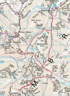
The above is the map of the route I took, it was 9.6 miles. I did this walk last year with my dad. Mapped it as I wanted to see how far it was and test the software.

1 comment:
That's neat!
Post a Comment